 JEFFERSON CO., Pa. (EYT) – A High Wind Watch remains in effect for Jefferson County and surrounding areas.
The National Weather Service of Pittsburgh issued the following Urgent Weather Message at 3:30 a.m. on Saturday, February 23, 2019:
High Wind Watch
URGENT – WEATHER MESSAGE
National Weather Service Pittsburgh PA
330 AM EST Sat Feb 23 2019
High Wind Watch in effect from February 24, 07:00 AM EST until February 25, 07:00 AM EST
COUNTIES:
Garrett-Tuscarawas-Carroll-Columbiana-Coshocton-Harrison-Jefferson OH-Muskingum-Guernsey-Belmont-Noble-Monroe-Mercer-Venango-Forest-Lawrence-Butler-Clarion-Jefferson PA-Beaver-Allegheny-Armstrong-Indiana-Washington-Greene-Westmoreland-Westmoreland Ridges-Fayette-Fayette Ridges-Hancock-Brooke-Ohio-Marshall-Wetzel-Marion-Monongalia-Ridges of Eastern Monongalia and Northwestern Preston-Preston-Eastern Preston-Western Tucker-Eastern Tucker-
CITIES:
Including the cities of Mountain Lake Park, Oakland MD, Grantsville, New Philadelphia, Dover, Carrollton, Malvern, East Liverpool, Salem, Columbiana, Coshocton, Cadiz, Steubenville, Zanesville, Cambridge, Martins Ferry, St. Clairsville, Caldwell, Woodsfield, Sharon, Hermitage, Grove City, Oil City, Franklin, Tionesta, New Castle, Ellwood City, Butler, Clarion, Punxsutawney, Brookville, Aliquippa, Beaver Falls, Ambridge, Monaca, Pittsburgh Metro Area, Kittanning, Ford City, Indiana, Washington, Canonsburg, Waynesburg, Murrysville, Greensburg, New Kensington, Ligonier, Donegal, Uniontown, Champion, Ohiopyle, Weirton, Follansbee, Wellsburg, Wheeling, Moundsville, New Martinsville, Fairmont, Morgantown, Coopers Rock, Kingwood, Bruceton Mills, Terra Alta, Rowlesburg, Hazelton, Parsons, Hendricks, Saint George, Davis, Thomas, and Canaan Valley
330 AM EST Sat Feb 23 2019
…HIGH WIND WATCH REMAINS IN EFFECT FROM SUNDAY MORNING THROUGH MONDAY MORNING…
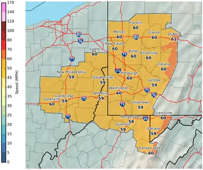
* WINDS…West 25 to 35 mph with gusts around 60 mph.
* TIMING…Strongest winds expected Sunday morning through Sunday evening.
* IMPACTS…Damaging winds will blow down trees and power lines. Widespread power outages are possible.
PRECAUTIONARY/PREPAREDNESS ACTIONS…
A High Wind Watch means there is the potential for a hazardous high wind event. Sustained winds of at least 40 mph, or gusts of 58 mph or stronger may occur. Continue to monitor the latest forecasts.
Copyright © 2024 EYT Media Group, Inc. All rights reserved. Any copying, redistribution or retransmission of the contents of this service without the express written consent of EYT Media Group, Inc. is expressly prohibited.


