 VENANGO CO., Pa. (EYT) – A Wind Chill Watch has been issued for Jefferson County and surrounding areas. Dangerously cold winds are possible.
Weather Alerts, brought to you by Redbank Chevrolet and DuBrook.
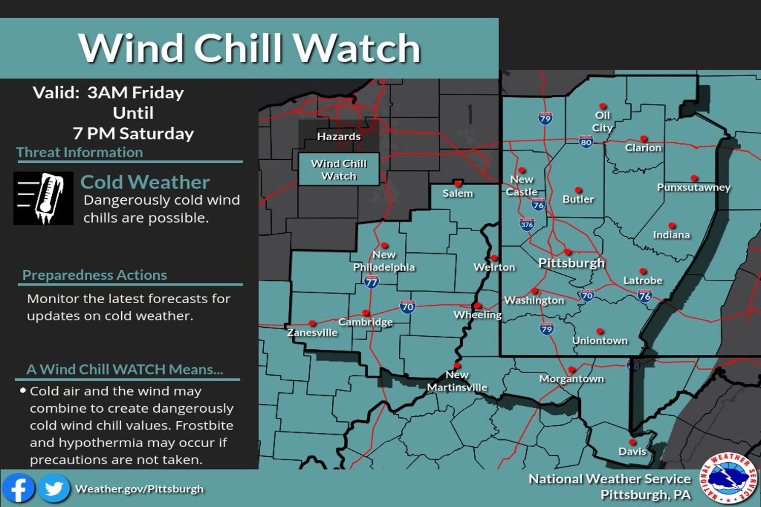
The National Weather Service Pittsburgh issued the following Urgent Winter Weather Message at 3:05 a.m. on Thursday, December 22, 2022:
Wind Chill Watch
URGENT – WINTER WEATHER MESSAGE
National Weather Service Pittsburgh PA
305 AM EST Thu Dec 22 2022
Wind Chill Watch in effect from December 23, 06:00 AM EST until December 24, 01:00 PM EST
ExploreClarion.com Weather Alerts for the Clarion County area are brought to you by Redbank Chevrolet and DuBrook.
![]()
COUNTIES:
Mercer-Venango-Forest-Lawrence-Butler-Clarion-Jefferson PA-Beaver-Allegheny-Armstrong-Washington-Greene-Westmoreland-Fayette-Hancock-Brooke-Ohio-Marshall-Wetzel-Marion-Monongalia-
CITIES:
Including the cities of Monessen, New Martinsville, Sharon, Butler, Canonsburg, Hermitage, Punxsutawney, Ambridge, Moundsville, Morgantown, Oil City, Lower Burrell, Kittanning, Ellwood City, Washington, Waynesburg, Beaver Falls, Wheeling, Clarion, Aliquippa, Follansbee, Fairmont, Brookville, Ford City, Greensburg, Murrysville, Grove City, Tionesta, Monaca, New Kensington, Uniontown, Weirton, Franklin, Latrobe, New Castle, Wellsburg, and Pittsburgh Metro Area
305 AM EST Thu Dec 22 2022
…WIND CHILL WATCH REMAINS IN EFFECT FROM FRIDAY MORNING THROUGH SATURDAY AFTERNOON…
* WHAT…Dangerously cold wind chills possible. Wind chills as low as 25 below zero.
* WHERE…Portions of northwest, southwest, and western Pennsylvania. Portions of northern and the northern panhandle of West Virginia.
* WHEN…From Friday morning through Saturday afternoon.
* IMPACTS…The dangerously cold wind chills could cause frostbite on exposed skin in as little as 30 minutes.

PRECAUTIONARY/PREPAREDNESS ACTIONS…
Monitor the latest forecasts and warnings for updates on this situation.
HIGH WIND WATCH ISSUED FOR JEFFERSON COUNTY AND SURROUNDING AREAS
The National Weather Service Pittsburgh issued the following Urgent Winter Weather Message at 3:05 a.m. on Thursday, December 22, 2022:
High Wind Watch
URGENT – WEATHER MESSAGE
National Weather Service Pittsburgh PA
302 AM EST Thu Dec 22 2022
High Wind Watch in effect from December 23, 03:00 AM EST until December 24, 07:00 AM EST
COUNTIES:
Tuscarawas-Carroll-Columbiana-Coshocton-Harrison-Jefferson OH-Muskingum-Guernsey-Belmont-Noble-Monroe-Mercer-Venango-Forest-Lawrence-Butler-Clarion-Jefferson PA-Beaver-Allegheny-Armstrong-
Indiana-Washington-Greene-Westmoreland-Higher Elevations ofWestmoreland-Fayette-Higher Elevations of Fayette-Hancock-Brooke-Ohio-Marshall-Wetzel-Marion-Monongalia-Ridges of Eastern Monongalia and Northwestern Preston-Preston-Eastern Preston-Western Tucker-Eastern Tucker-
CITIES:
Including the cities of Monessen, Davis, New Martinsville, Sharon, Butler, Salem, Canonsburg, Ligonier, Hermitage, Cambridge, Punxsutawney, Ambridge, Champion, Canaan Valley, Terra Alta, Moundsville, Caldwell, Morgantown, Oil City, Lower Burrell, Kittanning, Indiana, Saint George, Donegal, Woodsfield, St. Clairsville, Coopers Rock, Steubenville, Hendricks, Zanesville, Ellwood City, Carrollton, Washington, Kingwood, Malvern, Waynesburg, Beaver Falls, New Philadelphia, Clarion, Aliquippa, Ohiopyle, Follansbee, Wheeling, Coshocton, Hazelton, Fairmont, Brookville, Ford City, Dover, Greensburg, Columbiana, Cadiz, Murrysville, Bruceton Mills, Parsons, East Liverpool, Grove City, Tionesta, Monaca, New Kensington, Uniontown, Franklin, Latrobe, Weirton, New Castle, Rowlesburg, Martins Ferry, Wellsburg, Thomas, and Pittsburgh Metro Area
302 AM EST Thu Dec 22 2022
…HIGH WIND WATCH IN EFFECT FROM LATE TONIGHT THROUGH SATURDAY MORNING…
* WHAT…Southwest winds 15 to 25 mph with gusts up to 60 mph possible.
* WHERE…Portions of east central Ohio. Portions of northwest, southwest, and western Pennsylvania. Portions of northern and the northern panhandle of West Virginia.
* WHEN…From late tonight through Saturday morning.
* IMPACTS…Damaging winds could blow down trees and power lines. Widespread power outages are possible. Travel could be difficult, especially for high-profile vehicles.
PRECAUTIONARY/PREPAREDNESS ACTIONS…
Monitor the latest forecasts and warnings for updates.
Weather Alerts, brought to you by Redbank Chevrolet and DuBrook.
![]()
Copyright © 2024 EYT Media Group, Inc. All rights reserved. Any copying, redistribution or retransmission of the contents of this service without the express written consent of EYT Media Group, Inc. is expressly prohibited.


